This post is part two in a series focusing on circumferential transit in the Washington, D.C. region. Read the first post here.
The Washington region has a dearth of transit connecting its suburban areas, as I wrote in my first post in this series. Some people have latched onto the idea of extending the Purple Line into a loop around the Beltway to help remedy this problem. While it’s an intriguing idea, there are better ways to connect these communities.
The Purple Line had its origins in Montgomery County’s plan for a Bethesda-Silver Spring trolley using the then-newly-abandoned Georgetown Branch tracks. Since then, many people have come to see a full circle around the Beltway as the natural goal for the project.
Proposals for a full Purple Line loop, mostly along the Beltway, were floated as early as 2005 by the Sierra Club (below) and the Washington Regional Network for Smarter Communities (now part of the Coalition for Smarter Growth).
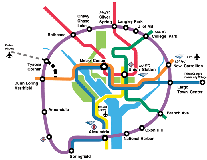
Full Purple Line loop as proposed by the Sierra Club in 2005. Image by Sierra Club, used with permission.
In 2006, Anthony Brown—then Martin O’Malley’s running mate for governor of Maryland—suggested that ‘‘We’d like to see the Purple Line go from Bethesda to across the Woodrow Wilson Bridge. Let’s swing that boy all the way around.” The idea dates back at least to Parris Glendening’s 1998 run for governor.
Extending the Purple Line on both ends, to Tysons Corner and to Largo, deserves further consideration. (In fact, I will discuss options for doing so in my upcoming posts.) However, extending it all the way around the Beltway is not the best way to provide good suburb-to-suburb transit connections to the communities that most need them.
Speed limits the length of light rail lines
Purple Line trains are expected to take one hour to travel the 16 miles from Bethesda to New Carrollton, for an average speed of about 16 miles per hour. That includes time stopped at stations, and isn’t unusual for a light rail line.
Extending the route further will not necessarily lead to longer trips for passengers. After all, most riders will only use a small portion of the line at any one time, and nobody except joyriding transit enthusiasts will ever ride more than half of a circle line on one trip (or they’d go the other direction instead). But very long travel times do pose problems from an operational perspective.
One problem is scheduling: minor delays can add up along the length of a line, making it difficult to maintain consistent waits between trains near the end of the line. This is even more an issue for light rail than for Metrorail, since light rail typically has to stop at traffic lights, and cross car traffic or even sometimes share lanes with cars. Delays due to traffic can make travel times quite variable in some cases.
As an example, if heavy traffic reduces a train’s average speed from 16 mph to 14 mph—a decrease of just 12.5%—the train will be seven-and-a-half minutes late after one hour, but 15 minutes late after two hours—a difference that can lead to unacceptably long waits between trains.
An additional problem is the need for driver bathroom breaks. A route that takes more than an hour or two to complete could pose significant difficulties for drivers. As a result, transit routes rarely exceed one to two hours.
The longest service on the New York Subway, the A train, takes roughly two hours to complete a 31-mile run. The London Underground’s longest lines travel further, about 40 miles, but they have fewer stops and generally complete their runs in about an hour and a half. Even San Francisco’s BART, with its famously long lines, takes about an hour and a half to run its longest service, the 50 miles line from Millbrae to Antioch.
Light rail is too slow for a Beltway loop
Given the Purple Line’s average speed of 15 miles an hour, a two-hour maximum run length would suggest a maximum route length of about 30 miles, less than half the distance around the Beltway.
An extension to Largo and Prince George’s Community College would add roughly six miles to the 16-mile line currently under construction, and an extension to Tysons Corner would add eight to 12 miles, depending on the route chosen. Adding both extensions would bring the length of the Purple Line to about 30 miles, and is probably the maximum reasonable length for the line.
To be clear, this does not mean that we cannot or should not build suburb-to-suburb connections beyond Tysons and Largo. However, it does suggest that these connections should be thought of as separate projects with transfers at major destinations, not as one continuous route.
Paris’s tram system is instructive. Paris tramway lines 3a and 3b form most of a light rail beltway around the French capital. But the belt route operates as two separate lines, with a forced transfer on the west side of the city. Neither individual line is more than nine miles long.
Theoretically that strategy could work in the Washington region too: break up a Beltway Purple Line into multiple segments. But if we’re going to break it up anyway, we may as well be precise about where we target lines, rather than haphazardly saying “just do a Beltway loop.” After all, even Paris’ loop is not complete, and Paris is a far denser and more transit-oriented city than Washington, with a loop that’s geographically a much smaller diameter than our Beltway.
A Beltway Metro line would not make sense
If the Purple Line’s relatively low speed as a light rail line makes it impractical to run the whole way around the Beltway, could it make sense to build a heavy rail Metro Beltway line instead? The higher speed and fewer stops of a heavy rail line would make it possible to complete the route—which would be about 65 miles, depending on the route chosen—in a reasonable amount of time.
However, while it would be possible to build a Metro line along the Beltway right-of-way, it would miss serving important destinations. A Beltway line seems to have first been considered by WMATA in 1994, and in 2011, WMATA included a Beltway ring line in a study of proposed Metrorail expansions.
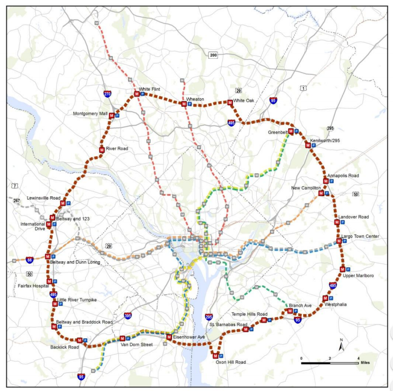
Beltway ring line proposed in 2011. Image by WMATA.
They predicted an increase of about 30,000 in weekday Metrorail boardings above a no-build alternative by 2040 if it was built. This is less than half the 70,000 riders estimated for the Purple Line from New Carrollton to Bethesda. Why is this significantly longer line predicted to have much lower ridership?
Station location is a big part of the answer. While the Purple Line will connect dense, walkable areas with large numbers of jobs—about 35,000 in downtown Bethesda, 20,000 each in downtown Silver Spring and at the University of Maryland, and 15,000 in New Carrollton—a line along the Beltway in the same area would serve much less dense areas at Grosvenor, Forest Glen, and Greenbelt before reaching New Carrollton.
While areas near new stations could potentially be upzoned to allow dense transit-oriented development, following the Beltway makes this more difficult. Land near freeways tends to be less desirable for housing and shops due to noise and air pollution, and the existence of the freeway itself tends to break up the walkability of the street grid.
WMATA’s proposal recognizes this problem and suggests—at significantly greater expense due to the need for a right-of-way—connecting the much less-walkable, car-oriented job centers of White Flint, Wheaton, White Oak, and Greenbelt to New Carrollton.
While White Flint is a job cluster similar in size to downtown Bethesda, White Oak has about 20,000 jobs and Wheaton and Greenbelt each have a quarter that many. These areas are not only much less walkable, they’re designed around commuting by car. They lack both the traffic and limited parking that make Bethesda, Silver Spring, and the University of Maryland appealing transit destinations.
Technically it would be possible to build Metro stations close to the same places as Purple Line stations, but doing so would require building it as subway for most of its length. Not one or two short subway segments, but dozens of miles of new subway tunnels, at astronomical expense. It’s possible, but not practical. Fitting snugly into tight urban spaces without needing as many expensive subways or elevated tracks is one of the major benefits of light rail, and it’s a significant part of why light rail was selected for the Purple Line in the first place.
A better alternative: Light rail and BRT lines where they’re needed
If a heavy rail Metro line around the Beltway was the only option for providing suburb-to-suburb transit connections in the Washington region, it might be worth considering more seriously. However, matching the line to the corridor more carefully, and using light rail or BRT lines to connect key circumferential destinations, is a better and more practical option that should be considered instead.
This general principle is that the densest suburban job and residential clusters in the region are not lined up in a single neat line, and aren’t all located right along the Beltway. Rather than build a single line that will miss important destinations for the sake of having a one-seat ride all the way around the Beltway (that nobody will use in that way anyway), we should focus on building shorter transit improvements that specifically connect important destinations.
There are a number of good potential routes for circumferential-esque light rail or BRT connections. Tysons, in particular, is a major destination. It could benefit from lines radiating out in several directions: connecting across the river to Maryland, southeast along Route 7 to Alexandria, and south along Gallows Road towards Dunn Loring and Springfield.
While a Gallows Road route would approximate the route of the Beltway, building it as a light rail line that could follow surface roads would allow it to more directly serve important destinations, most of which are set back from the Beltway some distance and lack obvious rights-of-way except for streets.
Important suburb-to-suburb transit routes that deserve better service exist in Maryland as well. In Montgomery County, the Veirs Mill Road-Randolph Road corridor connecting Rockville Pike to Wheaton is an important northern auxiliary to the Purple Line, and connects the two legs of the Red Line. While Montgomery County is planning a limited BRT line there, it is worth considering whether light rail, or at least a more significant busway, would be more appropriate than the improvements so far planned.
Likewise, in Prince George’s County, there are several potential corridors. Most notable is an extension of the Purple Line south from New Carrollton to Largo, but potential routes also exist along East-West Highway, Kenilworth Road, and Annapolis Road. In southern Prince George’s County, there are several corridors with enough density to potentially support light rail or BRT. They include Silver Hill Road, St. Barnabas Road, a connection from National Harbor to a Metro station, and across the Woodrow Wilson Bridge.
In the rest of this series, I will discuss at length the most promising of these potential lines, and suggest a few specific routes worth studying in more detail.
This article is part two in a series focusing on circumferential transit in the Washington, D.C. region. Continue reading part three.
This article also appeared at Greater Greater Washington.
DW Rowlands is an adjunct chemistry professor and Prince George’s County native, currently living in College Park. More of their writing on transportation-related and other topics can be found on their website. They also write for Greater Greater Washington, where they are on the Elections Committee. In their spare time, they volunteer for Prince George’s Advocates for Community-Based Transit. However, the views expressed here are their own.