The neighborhoods east of the Anacostia River have some of the longest commute times in D.C.—at or above 35 minutes on average (compared with 29 minutes District-wide), and over 45 minutes for those who use public transportation.[1] There is some Metrorail access, as the Green Line serves Anacostia and Congress Heights, and the Blue and Orange Lines serve neighborhoods north of Fort Circle Park. In between, however, residents must rely on bus transportation, which tends to be slower and, despite their lower fares, more costly to run.
The good news is that it is possible to improve public transportation east of the river by integrating buses and Metrorail better. While such integration would have positive citywide effects, it may also require a greater investment of public funds. Moreover, the physical and human geography in neighborhoods east of the river are unique, and require a more careful approach than a boilerplate public transit redesign.
Unique geographic difficulties
The New York-based think tank TransitCenter recommends “straight and direct” routes, without deviations, and bus network consultant Jarrett Walker considers the grid to be the most useful bus layout. However, the physical geography of D.C.’s east-of-the-river neighborhoods do not easily support such bus routes.
Straight bus routes intersecting at right angles require the street network to be a grid. While much of the District does have a cohesive grid, allowing for straight corridors such as 14th and 16th Streets Northwest or H Street North, the neighborhoods east of the river do not. There are very few north-south and east-west streets in these neighborhoods, and those only form small, local grids, such as in Fairlawn and Northeast Boundary, rather than large-scale grids of arterial routes that could host buses. Minnesota Avenue runs diagonally from Anacostia northeast to Deanwood, and could form a basis for a network of intersecting routes—but deviations and turns on local streets are unavoidable.
Ultimately, the lack of a large-scale street grid east of the Anacostia River comes from the hilly terrain. Hills make the street grid more difficult, but also make it harder for passengers to walk to the bus stop. This forces transit agencies to have more closely spaced routes, which reduces the frequency each route could have on a fixed budget, and more closely spaced stops, which reduces average speed. Pruning weaker bus routes is less feasible in such an environment: elsewhere, WMATA could require passengers to walk a quarter mile further to a more frequent bus, but in Southeast D.C., such a walk might involve going up and down a steep hill.
Consolidating routes would be easier if Metrorail were laid out at the intersections with the busiest arterial streets. Unfortunately, it is not. The most important street parallel to the river, Minnesota Avenue, connects the Green Line with the Orange Line, but misses the Blue Line. Major streets that cross the river inconsistently meet Metrorail stations west of the river: from Frederick Douglass Memorial Bridge, carrying South Capitol Street, to Benning Road Bridge, the only bridge that easily connects to Metrorail west of the river is the Sousa Bridge carrying Pennsylvania Avenue.
The impact of poverty
While some of the difficulties of designing a good transit system east of the river are purely about physical geography, it is impossible to ignore the fact that this area contains some of the poorest neighborhoods in the District. The three zip codes east of the river—20019, 20020, 20032—have median household incomes of $34,952, $33,196, and $33,832, respectively; the median income for the District as a whole is $72,935.[2]
The poverty of these neighborhoods impacts planning in at least two distinct ways.
The first is that a current bus route or Metro station may see substantial usage even if service is poor, if there are no alternatives. In higher-income neighborhoods, transit agencies can use simple data analysis to learn which routes offer the best service, because those are likely to be the busiest; middle-income riders will most likely not use low-quality routes, but instead take taxis, use ride-hailing services like Uber, or buy cars. But in low-income communities, such analysis would reveal very little, forcing WMATA to understand quality of service using theoretical insight into best practices, combined with outreach within the community.
The second implication is that if there are separate systems with separate fares, low-income workers will ride the cheaper system. Metrobus charges a flat $2 per trip whereas Metrorail charges more, for example $2.60 peak and $2.25 off-peak between Anacostia and Farragut. Moreover, passengers who transfer between Metrobus and Metrorail must pay two fares, so a combined trip from Southeast D.C. to Farragut costs $4.10 peak and $3.75 off-peak.
When Metrorail first extended the Green Line to Anacostia, the plan was to reroute the buses to serve the new station. This led to community protests over the higher fares charged to passengers transferring between the buses and the trains. Today, it is best to reroute buses to connect to Metrorail, a faster service with lower provision costs; however, workers east of the river will keep riding the buses alone if that option is cheaper, and would be disproportionately impacted by any proposal involving a large fare increase.
Is fare integration the answer?
In D.C., buses and Metro are on separate fare schedules: buses are cheaper, and there are no free transfers. This makes it difficult to have east-of-the-river buses feed Metrorail stations, as is common in cities with subway networks as strong as Washington’s, because people have an incentive to take the bus for the full length of their trip.
However, the best industry practice for running an effective transit network is fare integration. This means that a trip on public transit between two points should cost the same, regardless of whether it involves a one-seat bus ride, a connection between two buses, or a connection between a bus and Metrorail. Continental European cities almost universally have such a fare regime, even when it involves multiple different agencies. Many American cities such as New York, San Francisco, Seattle, and Los Angeles do as well, although they don’t incorporate their commuter rail networks. In those cities, planners can more easily reconfigure bus service to connect to the urban rail network; Seattle did, and as a result, its transit use and bus ridership have kept growing, even as its light rail (which opened in 2009) cannibalized some of its bus traffic.
Therefore, the best approach would be to bring Metrorail and bus fares in alignment. This could potentially raise costs for bus-only riders compared with what they are currently paying, but would make it easier for riders to take the fastest or more convenient option. It would also reduce operating costs: Metrorail is cheaper to operate than buses, and yet the fare system incentivizes taking the bus.
The most important thing to do is to make transfers free. At a minimum, WMATA should change the fare schedule on buses and trains so that passengers who transfer only pay the Metrorail fare, which is only moderately higher than the bus fare. But it would be better if the fares were exactly equal, as they are in so many other cities.
Fare alignment and equity
Fare integration is critical for the success of the public transit network, not just east of the river but in the entire region. But raising bus fares to match peak rail fares, potentially going up to $3 or even more between Anacostia and northern neighborhoods like Columbia Heights, would just make transportation less affordable to low-income Washingtonians, who are far more likely to be black or Hispanic.[3] A small fare increase may be conscionable, if it brings sufficient improvements in service and ridership in low-income areas, but not a large one.
This implies that within parts of the District, Metrorail fares need to decrease. The decrease does not need to be large; going to $2.25 flat fare within a central zone, including Anacostia and Minnesota Avenue, would have limited negative impact on revenue. It might even decrease operating subsidy, if low-income users transition out of high-cost buses and onto lower-cost trains. The highest-ridership bus route in the region, the 70 series, is closely parallel to the Green and Yellow Lines, and if passengers switched to Metrorail then it would free up resources to be spent on buses elsewhere in the District.
The impact of fare integration would thus be felt in the entire District and even in some inner suburbs, and not just east of the river. Fare integration would facilitate rearranging some key bus routes to feed Metrorail. The cost is that it would involve changing the fare system in the inner parts of the region, from today’s granular distance-based fare to a zoned system, in which the fare within the District is flat. In the suburbs, the distance-based system need not change, as there are relatively few local buses that could provide two different fare systems. Fare integration would certainly enhance equity, and might also increase efficiency to the point of saving money.
Ultimately, however, serving poor communities effectively requires spending public money. Improvements in public transit serving low-income communities may not always “pay for themselves” in terms of system costs, even when employing best industry practices; a more equitable system may therefore require spending a substantial ongoing investment of public funds in increased operating subsidies.
Rearranging the network
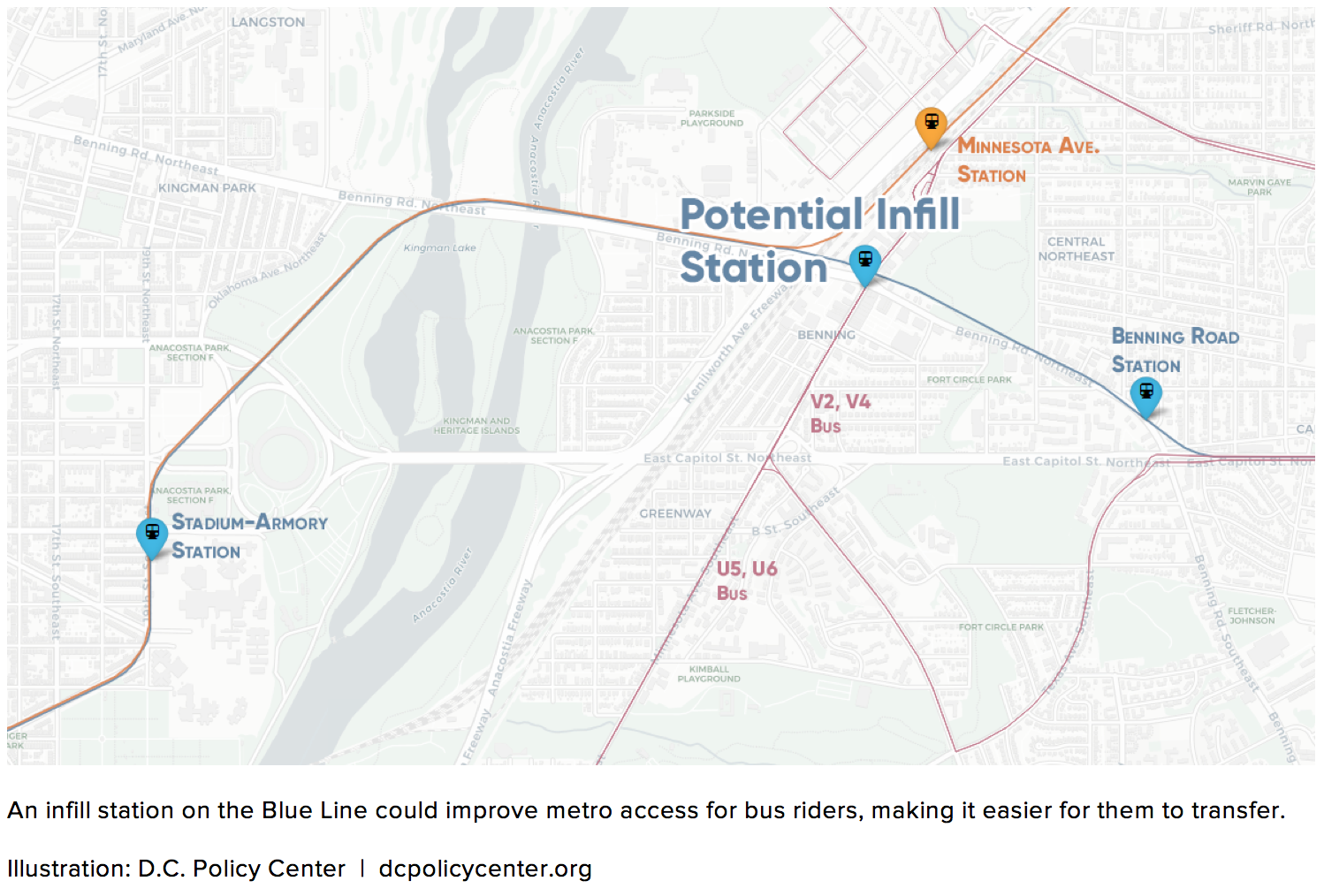
If WMATA implements fare integration between Metrorail and buses, then it can reconfigure the bus network east of the river to feed the trains better. With no north-south or east-west grid streets, it would need to rely instead on routes parallel to and perpendicular to the river. The most important is Minnesota Avenue; potentially WMATA should consider opening an infill station on the Blue Line, similar in scope to NoMa-Gallaudet U on the Red Line, in order to make it easier to transfer from Minnesota Avenue buses to the trains.
Additional important corridors include Pennsylvania Avenue, with the only bridge over the Anacostia whose landing west of the river connects easily to Metrorail (at Potomac Avenue on the Blue, Orange, and Silver Lines); and Alabama Avenue, parallel to Minnesota Avenue, connecting Congress Heights with Benning Road along the route of the W4 bus today.
Today, because the fare system encourages low-income riders to take buses all the way from their homes to downtown D.C., many buses east of the river divert to Pennsylvania Avenue. The only bus that goes along the entirety of Minnesota Avenue, the V2, comes every half hour off-peak. Instead, WMATA could be running a bus down Minnesota and rely on connections to Metrorail and to high-frequency buses on Pennsylvania Avenue. With less branching, fewer meanders, and less need to run buses across the river, there would be room for much higher frequency on each trunk. Minnesota Avenue could get a bus every ten minutes off-peak, maybe even every eight minutes.
Conclusion
Public transit east of the Anacostia River has unique challenges: difficult physical geography, Metrorail stations that are not placed for optimal bus connections, and very low incomes among riders. But it is possible to overcome these challenges; the area is not doomed to circuitous bus routes.
The central piece to improving the area’s public transportation is fare integration between buses and trains, through very small increases in bus fares and free transfers. With fare integration, passengers are likely to switch from buses to Metrorail, which has lower cost of service provision, which would allow pruning some bus branches. This has the potential to stimulate sufficient additional ridership that despite the decrease in fare collection, the overall public subsidy required may yet go down.
However, it is not guaranteed that a moderate fare change would be a net money-saver. Good public service for low-income residents is steeped with subsidies, everywhere: for health care, education, roads, housing, and transit. Adopting best industry practices may require an increase in public spending, but this investment would be worth it given the positive impact on connectivity to the rest of the city.
About the data
Data on household incomes and commute times are from the American Community Survey’s 5-year estimates for 2012-2016:
- S0802: Means of transportation to work by selected characteristics (by ward)
- S0802: Means of transportation to work by selected characteristics (by zip code)
- S1903: Median income in the past 12 months (by zip code)
Footnotes
[1] Source: American Community Survey 5-year estimates for 2012-2016. In Ward 8, the average commute time for residents who use public transportation is 48.8 minutes.
[2] Source: American Community Survey 5-year estimates for 2012-2016.
[3] According to American Community Survey 5-year estimates for 2012-2016, the median income of black households in the District is $40,560; the median income of Hispanic or Latino households is $60,848; the median income household of white (non-Hispanic) households is $122,593.
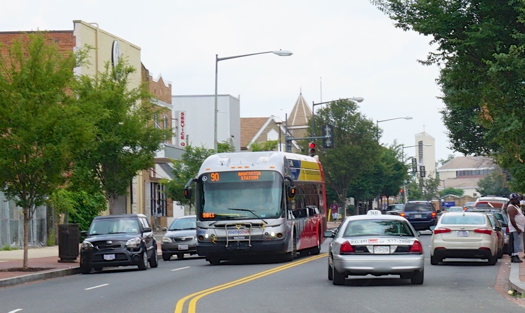
Feature photo by Ted Eytan (Source)
Alon grew up in Tel Aviv and Singapore. He has blogged at Pedestrian Observations since 2011, covering public transit, urbanism, and development. Now based in Paris, he writes for a variety of publications, including New York YIMBY, Streetsblog, Voice of San Diego, Railway Gazette, and the the Bay City Beacon. You can find him on Twitter @alon_levy.