This article is part six in a series focusing on circumferential transit in the Washington, D.C. region. Read part one, part two, part three, part four, and part five.
Maryland’s suburban areas have a dearth of transit connections, but better rapid bus service could help link many parts of Prince George’s and Montgomery counties. As I discussed in a previous post, a Purple Line extension south from New Carrollton to Largo should probably be built, but the Purple Line cannot meet all of the area’s suburb-to-suburb transportation needs.
While the line under construction will cross most of the width of Montgomery County, parallel circumferential transit is still needed further north in the county. South of Largo, Prince George’s main suburb-to-suburb connection needs lie inside the Beltway, significantly west of where the Purple Line will be.
The remaining corridors that need suburb-to-suburb connections are largely unsuitable for light rail because of steep grades and relatively low density. Instead, both counties should accelerate work on developing high-quality Bus Rapid Transit (BRT) corridors in these areas.
Montgomery County is getting rapid bus service, but will it be real BRT?
In Montgomery County, the Purple Line will serve the county’s most important east-west corridor with frequent service and limited interference from traffic. However, important east-west routes also exist further north, along Veirs Mill and Randolph Roads, which connect Twinbrook and downtown Rockville to Wheaton.
Both of these routes are served by major bus routes today: the Q4/Q6 to Rockville, and the C4 to Twinbrook. These are among the highest ridership bus lines in suburban Maryland today. While they’re unlikely to justify light rail, they are good candidates for BRT, especially since they run on roads wide enough to add dedicated bus lanes.
At present, one of the three planned lines for Montgomery County’s Flash BRT network is intended to connect the Rockville and Wheaton Metro stations along Veirs Mill Road. It has nine intermediate stops, with about one-and-a-half stops per mile.
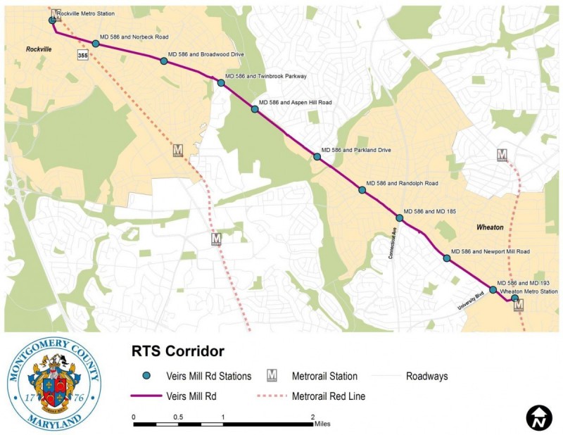
However, this route is still in the early planning stages. The preliminary design is only funded in the fiscal year 2023 county budget, so it is unclear if and when the line will actually be completed. Even if it is built, its utility will depend heavily on what exactly is built.
The Flash BRT network is intended to use level boarding and off-board fare collection, which reduce the amount of time buses spend stopped at stations and speed up service. However, while the recommended alternative for the Veirs Mill Road line does include queue jumps to allow buses to bypass congestion at major intersections, adding curbside dedicated bus lanes is only retained as the “long-term BRT alternative.” That suggests they will probably not be included in the initial line.
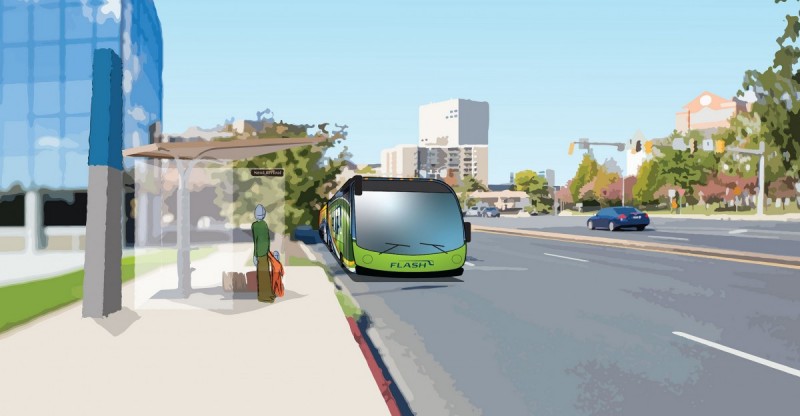
Downtown Rockville Flash BRT rendering by Montgomery County.
Not including dedicated bus lanes (ideally in the median) in BRT along this corridor will save money, but it is an unfortunate trade-off. Without dedicated lanes, buses will suffer from significantly longer travel times along this very congested corridor, which will take away some of the incentive to ride.
In addition to including dedicated bus lanes, a branch line running along Randolph Road to White Flint might also be worth considering. This area is becoming more important as a transit destination as density increases and a new street grid west of Rockville Pike at White Flint is being constructed.
Is BRT right for Prince George’s County as well?
While Montgomery County is at least moving in the direction of suburb-to-suburb BRT connections, Prince George’s County currently has no similar plans. In 2012, there was a report on potential transitways in Prince George’s, but it appears to have largely collected dust since then.
The county transportation department is currently looking at the possibility of adding weekend and evening service to its “TheBus” bus network; it currently has neither. While there are proposals to simplify and increase frequency on some routes, those plans are quite limited.
However, in addition to the Purple Line and to the Purple Line extension I’ve proposed, there are several suburb-to-suburb routes in Prince George’s County that are worthy of serious consideration for BRT or light rail. The broken-up nature of the road network in these areas, with most traffic funneled to a few congested arterials, makes it particularly important that transit—whether buses or trains—connect population and job centers, and do so without getting stuck in traffic.
If the county is serious about increasing density in its inside-the-Beltway suburbs, and about bringing new jobs and development to these generally less-affluent areas, it needs to find ways to improve transit connections.
Add BRT parallel to the Purple Line in Prince George’s
The Purple Line is being built along an excellent transit corridor, with dense and walkable (or at least potentially walkable) destinations all along its length. But while the Purple Line will connect as many good destinations as is practical, it still misses several places in northern Prince George’s County that merit a quality rapid transit connection. Thus, a parallel BRT line may make sense.
While running the Purple Line through the University of Maryland campus was the correct decision, it meant that the line was unable to serve the high density areas along Riggs Road and East-West Highway in the vicinity of the PG Plaza Metro station. A BRT line connecting the Takoma-Langley Transit Center to the Purple Line station at Kenilworth Road and East-West Highway would serve these areas, as well as the dense and diverse streetcar suburbs of Hyattsville and Riverdale Park.
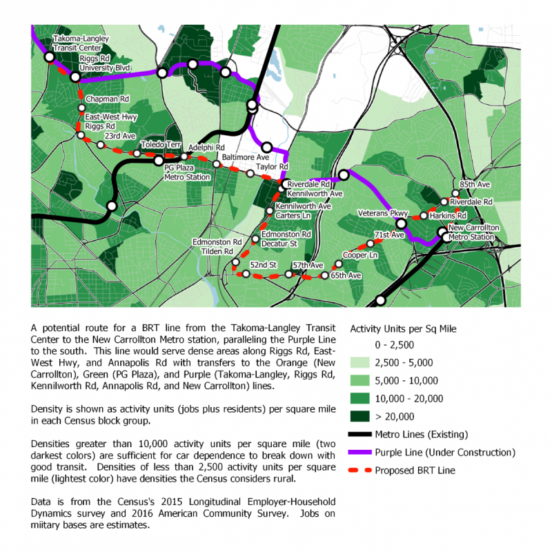
From Kenilworth Avenue east, it is somewhat less obvious what route should be served. One option would be to follow the remainder of the F4 bus route along Riverdale Road, serving several apartment complexes and shopping centers on the way to the New Carrollton Metro Station. This route serves more density than the actual Purple Line route—density the Purple Line was unable to serve because it involves grades too steep for light rail.
However, a longer and less direct route could potentially serve more dense locations, and would benefit more from speed improvements over current local buses. Kenilworth Avenue south of Riverdale Road is home to one of the densest portions of Prince George’s County. Continuing the BRT line along it to Annapolis Road and then along the heavily-trafficked Annapolis Road corridor to New Carrollton would provide a service that less directly duplicates the Purple Line.
Light Rail or BRT in southern Prince George’s County
While Prince George’s County inside the Beltway and south of US-50 is not as dense as the Purple Line corridor, it is the county’s poorest region. Despite a post-World War II road network that is not well-designed for transit or walking, it has a significant transit-dependent population.
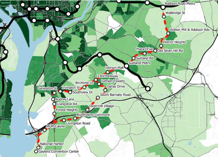
Extending the Purple Line into these areas would not work well, because the areas that most need service are further west than the Purple Line will be by the time it reaches New Carrollton or Largo. But they definitely need better suburb-to-suburb transit. The best option for serving them is likely a BRT or light rail line running northeast from National Harbor about halfway between the Beltway and Southern Avenue.
For the eastern half of this line, there is one obvious option: following Silver Hill Road and Addison Road from the Suitland Metro station to the Addison Road Metro station. With the exception of the segment along Addison Road, this route is relatively flat and follows wide roads, so a median transitway is an option worth considering. However, light rail might require an expensive tunnel to deal with the portion along Addison Road, as well as several other steep grades further south.
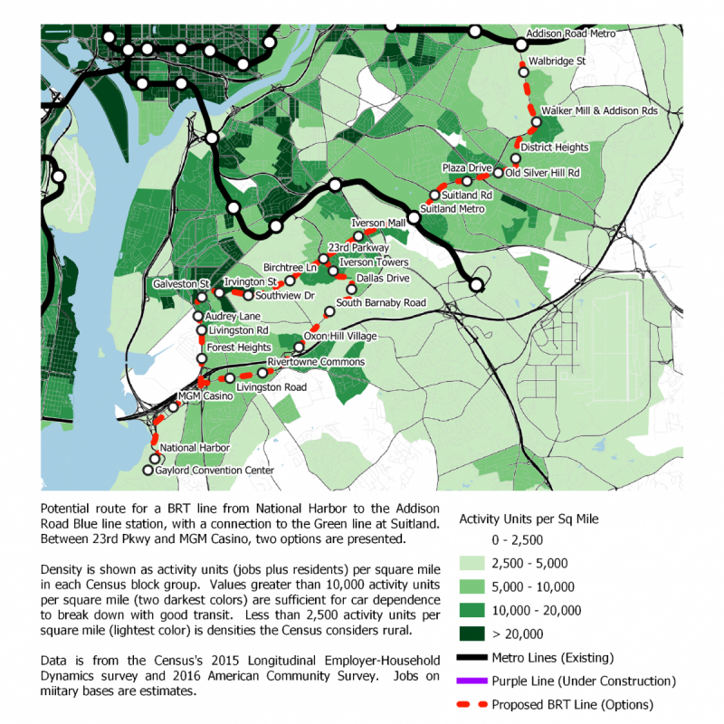
Southwest of the Suitland Metro station, two good options are apparent. The highest densities could be served by continuing along Silver Hill Road to Iverson Mall at Branch Avenue, and then following Iverson Street nearly to the intersection of Southern Avenue and Indian Head Highway before taking Indian Head Highway to National Harbor. This would require building two short connections through undeveloped land—including a bridge over Barnaby Run—to connect currently discontinuous portions of Iverson Street.
An alternative—which would serve less dense areas, but would not require building new streets and could offer more opportunities for new transit-oriented development—would be to run south from Iverson Street along 23rd Parkway and Raleigh Road to reach St. Barnabas Road and Oxon Hill Road on the way to National Harbor. In either case, the route would be roughly 11 miles long, with about seven miles between National Harbor and the Suitland Metro station.
Based on the Purple Line’s roughly 16 mph average speed, that would suggest about a half-hour travel time between National Harbor and the Green Line, and a 45-minute travel time from National Harbor to the Blue Line. This would however depend on the project having dedicated lanes and minimized interference from stoplights; a bridge over the particularly busy intersection of Silver Hill Road and Pennsylvania Avenue could help.
A shorter connection between National Harbor and the Green Line could be achieved at the Southern Avenue Metro station. However, such a route would need to run along Southern Avenue itself, given the rather limited street grid in the area. Southern Avenue may be too narrow to a dedicated right of way, and has more frequent intersections than routes further south.
While the Purple Line—the region’s first rapid circumferential transit link—gives the Maryland suburbs a head start over Virginia in building suburb-to-suburb connections, both Montgomery and Prince George’s Counties need to devote more effort to other important connections. In my next and final post in this series, I’ll discuss possible circumferential BRT and light rail routes within the District itself.
This article is part six in a seven-part series focusing on circumferential transit in the Washington, D.C. region. Continue reading part seven.
Feature image by the author. This article also appeared at Greater Greater Washington.
DW Rowlands is an adjunct chemistry professor and Prince George’s County native, currently living in College Park. More of their writing on transportation-related and other topics can be found on their website. They also write for Greater Greater Washington, where they are on the Elections Committee. In their spare time, they volunteer for Prince George’s Advocates for Community-Based Transit. However, the views expressed here are their own.